The Magnificent Zion National Park
One of nature's very amazing natural wonders!
Zion National Park is in southwest Utah, 160 miles north of Las Vegas
Millions of years ago this area was a desert bigger than the Sahara
Minerals in rain water, the immense weight of sand a mile deep and an endless supply of time turned a sand dune into a sandstone mountain.
The erosion caused by wind, rain, snow, glaciers and the Virgin River over the course of millions of years created Zion canyon.
The road through Zion Canyon is about 10 miles long
There are unique mountains like this one every step of the way
And both sides of the canyon are equally adorned
It's easy to imagine seeing many faces and figures in these rocks

Every mountain top is unique with it's own colors and shapes
The roads in Zion use sand from the region which blends in so well with the local color

The park has massive natural sand sculptures in every shape and color
And they are all over the park! Look at the lines and colors of this one

This is the Virgin River as it runs through Zion Canyon
Its hard to imagine that this small river was responsible for carving this entire canyon!
The Virgin River starts near Navajo lake north of Zion and empties into Lake Mead
It is one of the steepest rivers in the world, descending 8000 feet in only 200 miles

Here is the pedestrian entrance
If you are over 55, you can buy a senior pass for a one time charge of $20.
After that, you get a life time of free attendance at all national parks!
Sweet!

Zion National Park has many great hiking trails,
but Angels Landing seen here is the most spectacular
It got its name because it was thought that only an Angel could land there
Its a thin sliver of sandstone 1480 feet tall
centered in it's own round natural amphitheater

This post card picture was taken from the West Rim trail
You can see the finger of land that is Angels landing
And the series of 20 switchbacks that are called Walter's Wiggles

It looks like the trail is leading to a sheer wall,
but the trail goes most of the way up this mountain
before it turns into a tall narrow crevice

Here is looking back at the trail before the turn into the crevice

and here is what it looks like in the crevice

It's Walter's Wiggles!
Twenty short switch backs with a big altitude gain

This is what the last half mile and the last few hundred feet of elevation gain look like
The trail up to this point did not require you to use your hands
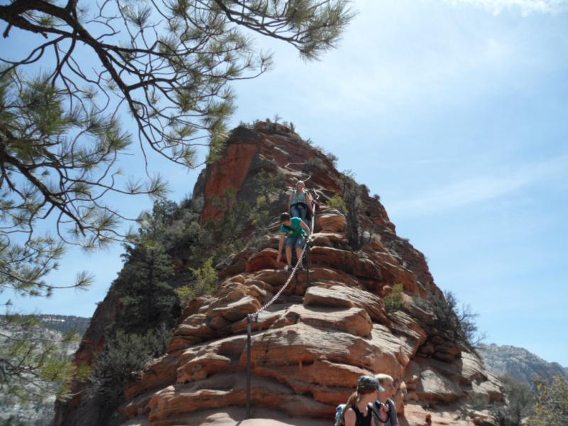
Past this point there are several sections of chains that are secured to posts that are anchored in the rock

For a large 14 megapixel picture, click on Close up
There are over a dozen people on the trail in this picture!
You can see them if you zoom in on the highly detailed close up
There are long sections guided by chain near the top of the trail
If looks scary from this vantage point, but it is not that bad with a thick chain for support
Just stop walking before you look around at the scenery, this trail demands your attention!

This is probably the scariest passage on the trail
The "trail" is on slanting sandstone almost too steep to stand on
It doesn't look it, but the fall is several hundred feet
I learned the meaning of "hold on for dear life"

This part of the trail will challenge your courage
Its about 1000 feet down on one side and 1200 feet down on the other!
They sort of put some steps in the trail, but they are uneven and irregular like the rest of the mountain

Here are some of the chains near the top of the hike
I think I also sat down where the lady is on the way down
The scary part being is a spot like this lady is,
and another hiker grabs the chain, which pulls on your part of the chain!
Finally at the end of the trail, a 2.5 mile journey and 1480 feet up
This is the view of Zion Canyon looking south

This is looking up the canyon to the north

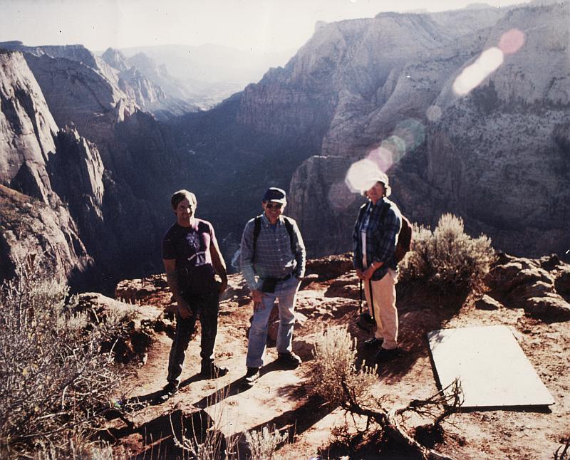
And here I am at the resting place of Angels

Here I am in a picture from about 30 years ago
This is the end of the trail to Observation Point
Its 8 miles round trip with an elevation gain of over 2100 feet
The first 3 miles are at a constant 13.5% grade and there is little to no shade
It's a difficult climb but the view from the top is spectacular
Angels landing can be seen in this picture,
its the ridge of land between my fellow hikers
Looking at this makes me wonder what happened -
With all of the tremendous forces of nature at work that created this canyon,
why did nature spare this peak and go around it for millions of years?
And why did nature go around a tall skinny sliver of land like Angels Landing?

Other Incredible parts of Zion National Park
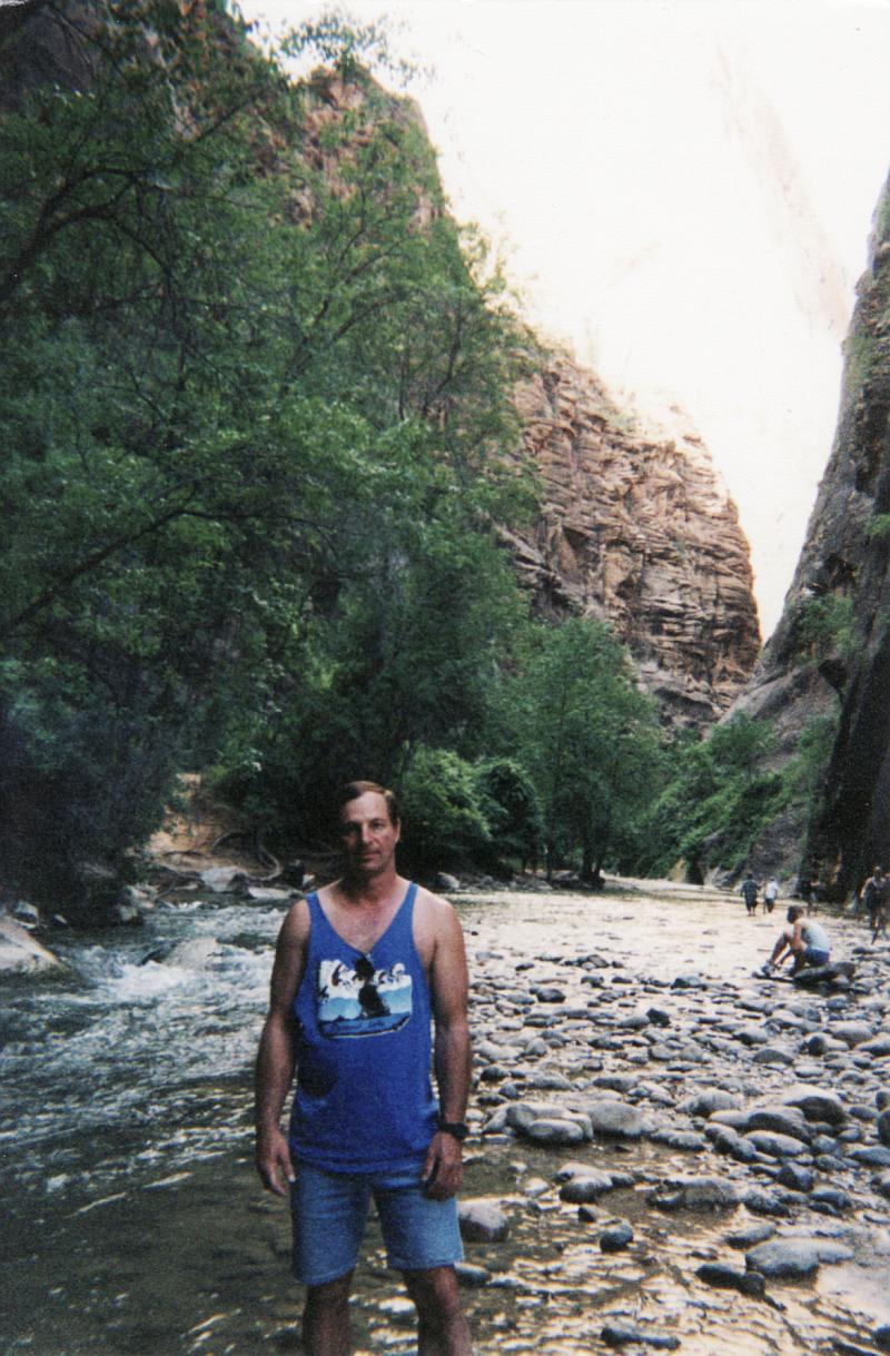
This is the trail to the Virgin River Narrows
At this point the canyon is relatively wide
Soon the canyon will narrow to only several feet

This is where the path ends and you have to walk in the stream
Try to wear sneakers with a lot of rubber around the outsides,
Walking on the slippery rocks makes your feet slide and hit other rocks
This is deep inside the Virgin River Narrows
Only a fraction of the height of the canyon walls are visible in this picture
The median width is 18 feet wide and the median height is 1800 feet,
mostly straight up on both sides.
The Narrows are just like this for well over 10 miles

This Hershey's kiss shaped mountain is Checkerboard Mesa
The horizontal lines were carved by glaciers
The vertical lines were caused by erosion
Look at the cars at the bottom to get an idea of the size of this mountain

Thanks for looking!
Home
You are unique visitor number [an error occurred while processing this directive] to this page
This counter was started on Nov 27, 2010
This page was last updated on May 27, 2020